Wayfinding observations: Landmarks and cardinal directions
When we come to a new city we build a cognitve map to represent this city in our minds. Unless you have photographic memory such cognitve maps work differently from topographic maps. They don’t consist of exact representations and distances, but are driven by landmarks and the paths that connect them. A landmark can be anything that clearly stands out from its environment, like a tower or a church. But one of the most important landmarks are rivers that divide a city. London is divided by the Thames, Paris by the Seine and Vienna by the Danube.
Last week I visited Vienna for the first time and experienced a typical wayfinding problem that always annoys me. From my hotel I wanted to make a sightseeing trip to the city center. I went to the closest subway station, paid my ticket and looked for a map to find out where I have to go. As you can see on the map, Vienna is divided by the river Danube. Since my hotel was close to the river I had no problem finding my position on the map, even though there was no You are Here mark.
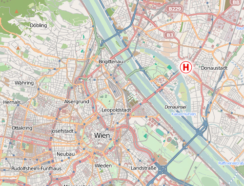
Source: openstreetmap, Creative Commons, by-sa
The city center was also easy to find and I can easily place it on my cognive map. It’s across the river and Southwest of my hotel.
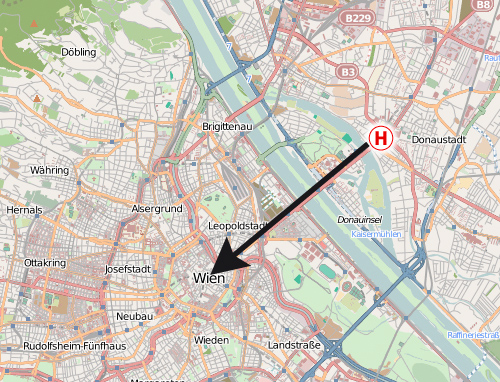
A subway line is directly connecting my position with the city center, so the only question left is which platform I need to take on this line. I know I want to go across the river, Southwest and to the city center—but none of these information is given to me. Instead I get:
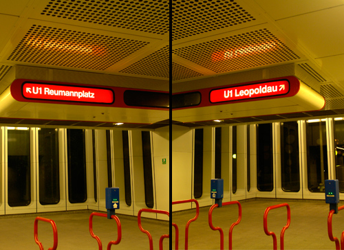
Do I want to go Reumannplatz or Leopoldau? Well, neither! I want to go across the river, Southwest and to the city center…
So I need to check this huge and very detailed map again to find those terminal stops. From a cognitive perspective this is really a problem. Especially tourist will never visit those terminal stops, so to them they are meaningless, hard to remember and hard to place on a cognitve map. But cardinal directions and landmarks are basic tools of navigating thru the environment and would make it much easier to travel around an unknown city. What about an additional information which of those platforms leads to the Northeast and which to the Southwest? Even a simple circled SW and NW would probably suffice.
But getting on the right platform is not the only problem—it continues when we want to exit the subway. I got off at my stop in the city center. It’s a large subway station and after walking thru the subway catacombs I will usually have lost my sense for the cardinal directions again. From the topographic map I looked at in the other subway station I know I want to go Northeast from the station and stroll thru the city there, but what I get is:
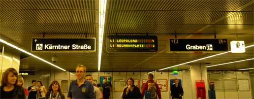
Do you want to exit to Kärntner Straße or Graben? Well, I don’t know! I want to go to the Northeast! How should I know all these street names as a tourist? And even if I would know the right street name, without cardinal directions I wouln’t even know which direction I should take on that street. So I need to consult a topographic map again to check random street junctions which might help me determine in which direction I am currently standing. A simple compass rose on the ground would have made it much easier…
It’s not a secret how cognitve maps work and how tourist move thru a city. But it seems that the signage of most public transport systems don’t really reflect that. They seem to be more driven by a strict and logic engineer’s approach, rather than how people actually use these systems. What are your experiences? Am I the only one who wants to rely on landmarks and cardinal directions when navigating thru a city? Do you know cities with a signage system that accommodates our cognitve maps in a better way? In which cities do you got lost and why?
I have the same problem with subway exit navigation signs! Thank you for articulating it. I think they are catered to locals who know the streets, but adding a simple N,S,E, or W next to each name would appease those of us who are using a map.
Thanks for sharing your findings on Vienna. Another example of cities sign and wayfinding systems that don’t work together, a common problem for navigation and orientation in many cities wordwide.
I agree with you that the names of the streets are somewhat meaningless to tourists but In general I don’t believe by adding cardinal directions (N,S,E and W) will solve this, as most Europeans (execpt UK) don’t know where North is in an unknown environment. I believe the solution begins by adding (city) landmarks to a map and make all the city sign systems work together (same names, areas, maps, directional signs, etc.)
In London similar problems where playing a part in city navigation and orientation, AIG started the project http://www.legiblelondon.info/ where they intersect the different parts on how to navigate through a city for example by usins head-up maps and details on orientation by placing 3D buildings on the map on all ways of communication.
If you would have known the walking distance in time, what would be an acceptable time for walking for you? And would you prefer walking above public transport while visiting a new city?
This reminds me of the first time that I went to Boston for a conference. When I was trying to get back to the airport, I was unsure of the direction that I needed to go to when I switched trains. Turns out that I got on the train going the wrong direction, but, to make matters worse, the announcements over the PA system were wrong. So I thought that the next station would be then one I want, even though it was not! It was not until I crossed the Charles River that I was able to reorient myself, and realize that I was going the wrong way.
Really interesting articulation of this problem! I found the San Francisco subway (BART) especially confusing. On top of the sorts of problems you mention, the signage at the platform for the trains themselves is very confusing.
Amen to that!
I didn’t even noticed there was a subway system in San Francisco when I was there. I was busy enough to figure out the bus system.
See Erik Spiekermann’s observation: http://spiekermann.com/en/san-francisco-walks-1/
And according to this article:
http://adactio.com/journal/1608/
the Thames, London’s most important landmark, has been removed from the tube map.
Interesting article but it sounds like you would have better served if you carried a compass rather than asking the city in question to add 10s of thousands of dollars, if not more, worth of improvements to it’s transit system. I am not trying to be a smart ass but everyone navigates differently and while cardinal directionals may have helped you it may have helped the next guy.
@Bill: I agree that people navigate differently, but I also think it comes down to very few general principles. And a good wayfinding system should give access to all of them, instead of just one. Don’t you think?
Hi!
Congratulations! Your readers have submitted and voted for your blog at The Daily Reviewer. We compiled an exclusive list of the Top 100 typography Blogs, and we are glad to let you know that your blog was included! You can see it at http://thedailyreviewer.com/top/typography/2
You can claim your Top 100 Blogs Award here : http://thedailyreviewer.com/pages/badges/typography
P.S. This is a one-time notice to let you know your blog was included in one of our Top 100 Blog categories. You might get notices if you are listed in two or more categories.
P.P.S. If for some reason you want your blog removed from our list, just send an email to angelina@thedailyreviewer.com with the subject line “REMOVE” and the link to your blog in the body of the message.
Cheers!
Angelina Mizaki
Selection Committee President
The Daily Reviewer
http://thedailyreviewer.com
Great article Ralf, I always seem to get lost in London even though I have been there hundreds of times. For a tourist I can imagine this would be hell especially as their underground signage doesn’t accommodate large landmarks either.
Hi Ralf! and like in Vienna the most useful thing is, what you seem to have missed: The “Umgebungsplan” (in Vienna), the map of the sorrounding. There the underground layout, plus the exits, plus the neighborhoods are shown, which makes it easy to find your way in and out.
I have to disagree in some points: The underground is made not for tourists, it is made for the inhabitants of the city, and should help them foremost, while at the same time help tourists.
I myself being from Vienna (but living abroad) would have problems if at the underground station Stephansplatz there would be something else written but “Kärtnerstraße” and “Graben”, because this is what 90% of the passengers are checking for.
I agree with the cognitive map, I found myself recently in Tokyo subway (the stations there are way bigger than Vienna’s
Watch out for them on your next trip, they are the real safers.
One more thing: Putting NW or SE onto the map would be a complete waste. How many people have an imagination about cardinal directions and can think in them? Not many. OTOH, I agree that putting something like “City Center” on the direction would help, and AFAIR the newly made metro stops in Vienna give these directions (check out the new U2 stops and the U3 stops).
Still, very interesting to read.
Thanks a lot
In defense of the wayfinding system presented here (even though I also would have done it differently):
THis is a classic case of selective perception. It is not true that ‘none of these information is given to me’. People usually refer to a subway map like this one: . These maps can be found virtually everywhere in the subway system. The city center, other places of interest, even the river, are on it. As a result, I usually know beforehand to which station I want to go, even as a tourist. I believe most people do. And on such a subway map, it’s very easy to find out in which direction you have to go.
This leads me to two conclusions: First, there is no need to find the subway lines on a topographic map. Plus, putting the directions on the boards usually is the only thing you need by the time you get to those boards.
So, why should all the information a tourist possibly could need be cramped into those overhead signs?
This is so true - good observation.
Here in Oslo, Norway it’s very confusing as there are stops on the lines heading west with the Norwegian word for east, (“øst” - and the stop Østerås) and with the word for west on the lines heading east (“vest” and the stop Vestl). So tourists trying to figure stuff out may be tricked going the wrong way.
Well, i know for a fact that London, as i live here, has a very good transport system. The use of “eastern” “western” “northern” and “southern” words to identify the general direction you wish to go. Also, most major tube stations have direction boards which take you to road names, or points of interest, via different exits.
The use of the free mini tube maps are a great help too, as they allow you to see roughly where you are, in relation to the Thames, not accurate of course, but enough so to give you a general idea.
Ralf - i’ve taken a little time out here in London, to catch up with the latest thinking…it’s been an enjoyable journey - an admirer of Ladislav Sutnar 1897 to 1996 [i'd have have loved to have met him in person] and just yesterday i discovered Marian Bantjas …wow [and bought 'I Wonder' [2nd hand last night]
and today your blog and the type face for motorway signage - great work by the way …great read and your style of explanation is 1st class, so thank you
Meanwhile i have a small comment i’ve drive some 30k miles a year and of course appreciate we have one of the finest motorway wayfinding systems. Which brings me to Belfast where i found such a lack of street names as i drove with ‘strangers eyes’ that i resorted to a car dashboard mounted compass, working on the theory that i was travelling west when i entered and wanted to be travelling west when i left, i then relaxed into the many winding routes that led west eventually, of course i could have spent a lot of money and upgraded my tomtom to help but it worked and still works for sudden ridiculous one way routes that spring up…..so to cut along story short, i agree with you… i use compass notation because i understand it’s simplicity
Of couse my iphone 4 has now become the ‘you are here’ sign we so often need, but not everyone is fortunate enough to have one to hand
just to add I found a great colour blindness simulator for those of us that have fully functioning RGB cones! - the camera view on the phone can be switched on and on the fly to show the varying colour shades seen with the 3 main types of colour blindness and for 59pence worth every penny. It’s called CVSimulator on iTunes [but i have stolen the thread so shall stop here]
Again Ralph thank you..i shall be back soon
tom bassett
graphic designer | sign surveyor | wayfinding analyst | typographer | risk assessor | and elder statesman
There’s a simple way to integrate cardinal directions into the urban image without additional cost: http://manholecovers.de/windrose
The only problem is to sensitize the guys at civil engineering department that these covers have to be installed in the right direction, which is’nt successful always. Sadly, in this case, it was’nt.
@Tom - London yes…me to, but do you know my biggest hate on the underground in particular?
we drive on the left here in the uk, but just few long connection tunnels [on foot of course] have just a little wall plaque saying ‘keep to the left’ which everyone fails to see and do…and then the managers of the system just fail to say it ever again…so going up and down stairways…..you can meet huge cases coming up both sides of a stairway….!!
i don’t mind which side they choose to have us walk but just say something, instead of letting everyone bump and dodge… and no respect for the less able either
I emailed ken livingstone’s [ex mayor of london] personal e-mail many times, and it was always the same story a minion would reply for him, saying ‘he wasn’t able to do anything about it!’ - i must ask boris the same question…
it’s these small details that make such a difference to the wayfinding experience,…especially for tourists and strangers eyes…more time to see the way and less time watching for people walking into you
cheers tom2
Unfortunately it really doesn’t matter they way we start to think and design the wayfinding. They are studying that proved that people are using less the logic and the communication skills to help them self out. They completely rely on technology such as smart-phone, gps and so on. I’m base in London and I see tourists every single day. I noticed that quite a lot of them don’t even need to understand the tube map because they have all journey planned on the phone. Do you think is the case that designer start to embrace the technology and build beautiful applications instead than leave it to developers and web designer?
Sure, GPS devices change the way we navigate thru a city dramatically. But the problem of “providing orientation within a spatial framework” is also not solved by such devices at the moment. There is still room for improvement.
And of course, at the moment, we cannot fully rely on such electronic devices – for example, if they don’t work in the subway …
@drainspotter - yes the orientation problem…but in the long term, if this idea was adopted properly,
All that is needed is the redesign [tooling of the frame and drain] to have a ‘puzzle like nodule’ that locks it into a one way position